$75,000
$80,000
6.3%For more information regarding the value of a property, please contact us for a free consultation.
36.88 Acres Lot
SOLD DATE : 04/11/2022
Key Details
Sold Price $75,000
Property Type Vacant Land
Sub Type Residential
Listing Status Sold
Purchase Type For Sale
Subdivision Sunrise Country
MLS Listing ID 1788919
Sold Date 04/11/22
HOA Fees $8/ann
HOA Y/N Yes
Annual Tax Amount $50
Lot Size 36.880 Acres
Acres 36.88
Lot Dimensions 0.0x0.0x0.0
Property Description
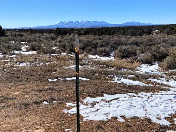
Fresh air, some wooded and some tillable areas with splendid views of mountains. A small structure exists on the lot. Could be used for lodging along with a camp trailer while you make your own improvements. Off grid, no utilities. Acreage is reported to be 36.88 acres but could vary slightly. The seller offers water that can be hauled from a well to this site. Endless opportunities to explore this lot and the area via trails and nearby BLM lands. Seller explains that the CCRs were never legally "perfected" and are therefore not enforceable.
Location
State UT
County San Juan
Area Monticello
Zoning Single-Family, Agricultural
Direction From Monticello: 12.6 miles East of Monticello on HWY 491, turn left (north) then 17.2 mile North on West Summit Rd CR 313, travel to T in the road where pavement ends turn west (left) on Bryan Road CR 324, go 1 mile, turn North on Old Summit Rd County Rd 318, look for red arrow pointing right, pass Deer Neck Rd and continue to Sunrise Country. Theres another red arrow, road winds around east then south. Look for Real Estate Resolutions sign. (fallen in the snow) From LaSal: Watch for cows and deer! Take the Lisbon Mine Road, the first major road that goes South (right) before you come to LaSal. Stay to your left the rest of the way, dont ever veer to the roads on the right until you reach the top of the mesa. Go past the mine to the top of the mesa. Road turns right-west on to Bryan Rd. (theres a yellow arrow that directs you) Continue West. The paved road will end, continue on the dirt road almost a mile to CR 318, Old Summit Rd. Theres a red arrow sign pointing right or north. Pass Deer Neck Rd and contin
Interior
Fireplace false
Exterior
Utilities Available Electricity Not Available, Sewer Not Available, Sewer: Septic Tank
Waterfront No
View Y/N Yes
View Trees/Woods
Present Use Residential,Agricultural
Topography Terrain: Grad Slope
Private Pool false
Building
Lot Description Additional Land Available, Terrain: Grad Slope, View: Mountain, Wooded
Faces East
Sewer None, Septic Tank
New Construction No
Schools
Elementary Schools Monticello
Middle Schools None/Other
High Schools Monticello
School District San Juan
Others
Senior Community No
Tax ID 31S25E147800
Acceptable Financing Cash
Horse Property No
Listing Terms Cash
Financing Conventional
Read Less Info
Want to know what your home might be worth? Contact us for a FREE valuation!

Our team is ready to help you sell your home for the highest possible price ASAP
Bought with Moab Premier Properties


