$210,000
$225,000
6.7%For more information regarding the value of a property, please contact us for a free consultation.
21.41 Acres Lot
SOLD DATE : 12/01/2023
Key Details
Sold Price $210,000
Property Type Vacant Land
Sub Type Residential
Listing Status Sold
Purchase Type For Sale
Subdivision Grass Creek
MLS Listing ID 1902383
Sold Date 12/01/23
HOA Fees $62/ann
HOA Y/N Yes
Annual Tax Amount $149
Lot Size 21.410 Acres
Acres 21.41
Lot Dimensions 0.0x0.0x0.0
Property Description
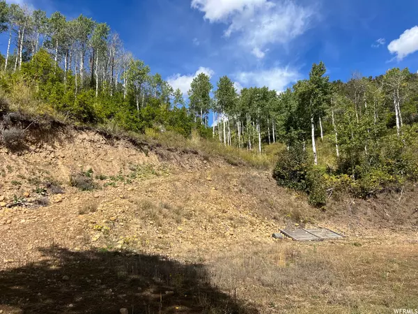
This property is ready to start enjoying your mountain get away in the beautiful private area of Grass Creek east of Coalville. Lot 6 has been excavated for several recreational vehicles to camp. There is a picnic area to relax and enjoy the changing of the seasons. There is an ATV trail that goes to the top of the mountain. Cell service is available from the top. There are no utilities on the property. The surrounding cabins have wells, generators or solar for power, septic tanks and propane. This lot is perfect to build your dream cabin. The road access is seasonal with snowmobiles or snowcats to access in the winter. No subdividing of lots. There are 27 lots total in Grass Creek.
Location
State UT
County Summit
Area Coalville; Wanship; Upton; Pine
Direction Lot 6, Grass Creek Estates does not have an official address. The closest address to come up on the GPS is 1431 Moose Hollow. See attachment for directions. 41.00561° N, 111.27533° W NS-1091-5 Legal: LOT NO 6 BEG AT A PT IN THE C/L OF A 50 FT ROADWAY BASEMENT RESERVED TO PUBLIC USE FOR INGRESS & EGRESS WH PT BEARS N 78*2028" E 7796.19 FT FROM THE NW COR OF SEC 17 T3NRGE SLBM; TH ALONG SD C/L AS FOLLOWS: S 69*0330" W 334.29 FT; N 76*09°30" W 241.93 FT; N 64*1630" W 230.11 FT; TH LEAVING SD C/L & CONTINUING N 4*0520" E 1532.69 FT; TH N 88*3850" E 250 FT; TH S 18*4210" E 1528.40 FT TO A PT IN THE C/L OF THE ABOVE DESC ROADWAY EASEMENT: TH ALONG SD C/L S 37*0820" W 157.16 FT TO PT OF BEG CONT 21.41 AC 884-591 1801-1748 1887-1442-1396
Interior
Fireplace false
Exterior
View Y/N Yes
Present Use Residential
Topography Terrain: Grad Slope, Terrain: Hilly
Private Pool false
Building
Lot Description Terrain: Grad Slope, Terrain: Hilly, View: Lake, View: Mountain, Horse Property
New Construction No
Schools
Elementary Schools North Summit
Middle Schools North Summit
High Schools North Summit
School District North Summit
Others
Senior Community No
Tax ID NS-1091-5
Acceptable Financing Cash, Conventional
Horse Property No
Listing Terms Cash, Conventional
Financing Cash
Read Less Info
Want to know what your home might be worth? Contact us for a FREE valuation!

Our team is ready to help you sell your home for the highest possible price ASAP
Bought with NRE


